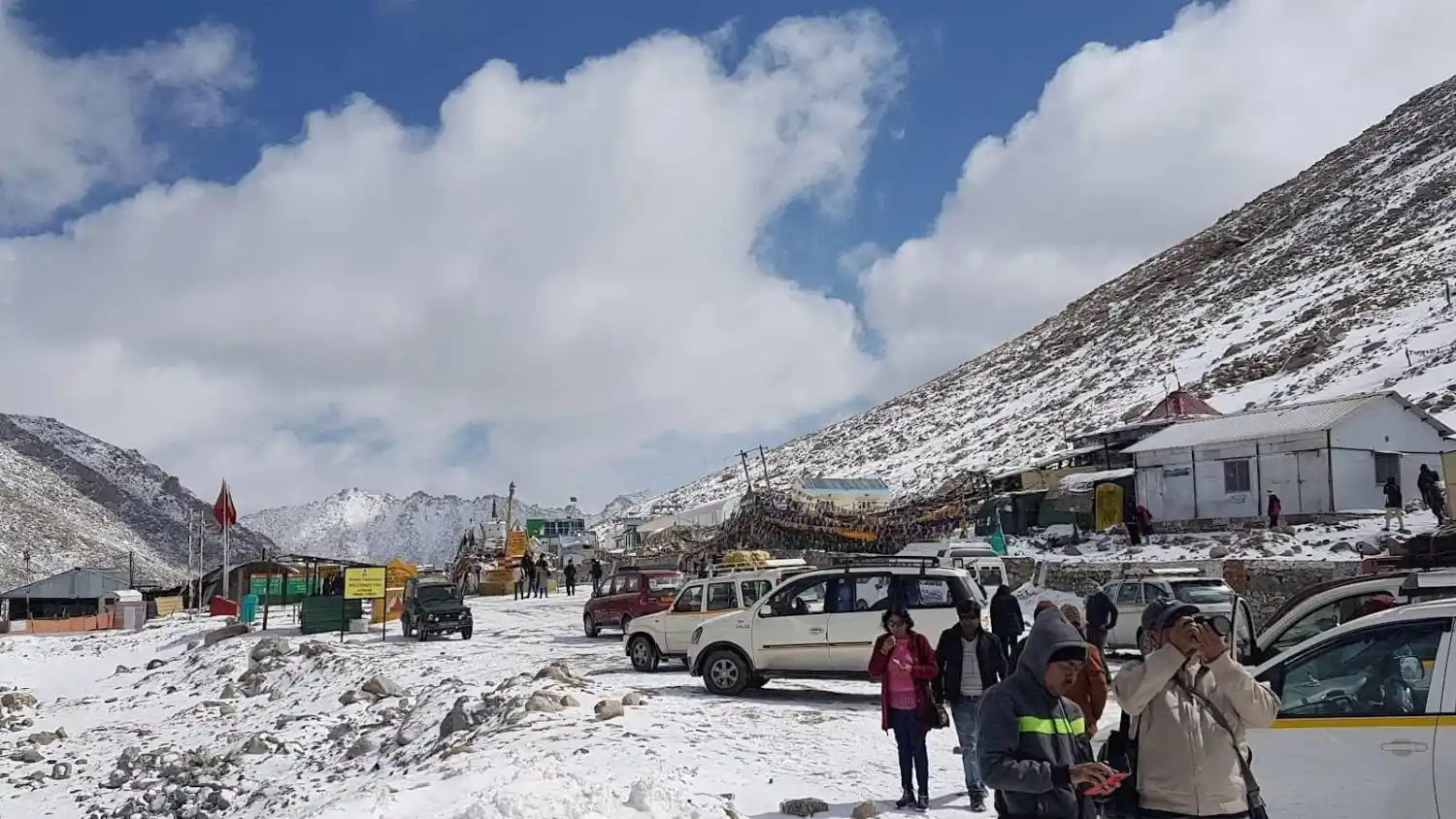
If you are travelling from Leh to Pangong Lake by road, Chang La Pass will naturally become part of your journey. You do not have to plan a separate trip just to see it. As you leave Leh behind and move past Karu and Sakti, the road slowly starts climbing higher. The villages become fewer, the mountains feel closer, and the air gets colder.
Reaching the top of Chang La Pass is exciting, especially on your first Ladakh trip. But this is also a place where you need to listen to your body. The altitude is very high, so your stop should be short and relaxed.
Take a few photos, visit the small Changla Baba Temple, have a hot drink if available, and continue towards Tangtse and Pangong Lake.
This guide explains the complete route, altitude, road experience, best time, nearby places, permits, and safety tips you should know before crossing Chang La.
Chang La Pass at a Glance
| Factor | Details |
| Location | Ladakh, on the common Leh-Pangong route |
| Altitude | Around 5,360 metres or 17,500+ feet |
| Best Known For | High-altitude road journey and route to Pangong |
| Main Route | Leh → Karu → Sakti → Chang La → Tangtse → Pangong |
| Connects | Leh side with eastern Ladakh and the Pangong region |
| Ideal Stop Duration | Around 10–20 minutes for most travellers |
| Best Time to Visit | Usually late spring to early autumn, depending on road conditions |
| Best Time to Cross | Earlier in the day |
| Suitable Vehicles | Motorcycles, taxis and suitable cars |
| Main Concern | High altitude and changing weather |
| Permit Requirement | Depends on current rules and onward destination |
| Common Next Destination | Pangong Tso |
What Is Chang La Pass and Why Will You Cross It?
Chang La is a high mountain pass in Ladakh that many travellers cross while going from Leh towards Pangong Lake.
For most tourists, it is not a separate destination where you arrive in the morning and spend the entire day sightseeing. It is part of the road journey.
And that is exactly what makes it interesting.
When you start from Leh, the first part of the journey feels relatively comfortable. You pass settlements and drive along better roads. As you move towards Sakti and then Zingral, the road starts climbing.
By the time you reach Chang La, you are standing at an altitude of around 5,360 metres.
You immediately notice the difference.
The wind feels colder. Walking quickly can leave you short of breath. Even a simple climb from your vehicle to the signboard may feel more tiring than expected.
According to local tradition, the pass is associated with Changla Baba, and a small temple at the top is visited by many drivers and travellers.
You can stop, take photos, and look around, but remember one thing: Chang La is best experienced as part of the journey, not as a long sightseeing stop.
What Does the Chang La Journey Actually Feel Like?
The road to Chang La is where the real experience begins.
If you start from Leh early in the morning, the first part of your drive may feel easy. The roads around Leh and Karu are generally more comfortable compared with the high-altitude sections ahead.
After turning towards Sakti, you start leaving the wider Indus Valley behind.
The road climbs gradually.
At first, you may not feel much difference. But as you continue towards Zingral, the landscape becomes more open and empty.
You see fewer houses.
The mountains look rougher.
The temperature starts dropping.
Depending on the month, you may also see snow patches beside the road.
The section closer to Chang La needs more attention. Road conditions can change because of snowfall, melting snow, water crossings, repair work, and changing weather.
Do not expect the road to look exactly like the video you watched before your trip.
Someone travelling in June may find snow and wet sections. Another traveller using the same road in September may experience completely different conditions.
If you are travelling in a taxi, the journey can feel easier because experienced local drivers know these mountain roads.
On a motorcycle, you have much more to manage yourself. You need to watch the road, control your speed, handle cold weather, and pay attention to how your body is reacting to the altitude.
Once you reach the top, do not jump out of the vehicle and start running towards the signboard.
Move slowly.
Take a moment.
Your body is now at a much higher altitude than Leh.
After your short stop, the road begins descending towards Tangtse. As you lose altitude, many travellers start feeling more comfortable again.
From Tangtse, you continue deeper into eastern Ladakh towards Pangong Lake.
That is why crossing Chang La feels like more than simply visiting a mountain pass. You can actually see and feel the landscape changing throughout the journey.
Chang La Pass Altitude: What Travellers Should Actually Know
The Chang La Pass altitude is around 5,360 metres, or roughly 17,500+ feet above sea level.
That number may not mean much until you actually reach the top.
At this altitude, less oxygen is available to your body than at lower elevations. This is why even simple physical activity can feel tiring.
You may notice that you are breathing faster after walking only a short distance.
Some travellers may experience:
- Headache
- Dizziness
- Nausea
- Unusual tiredness
- Shortness of breath
Not everyone will feel the same symptoms.
Some people may feel completely fine during a short stop, while others may become uncomfortable quickly.
Do not compare yourself with other travellers.
If your friends are running around taking photographs and you feel dizzy, sit down and tell someone.
Move slowly and avoid unnecessary physical effort.
If you experience serious or worsening symptoms, continuing the trip just to complete your itinerary is not a good idea. Descending to a lower altitude and getting medical help should come first.
How Long Should You Stay at Chang La Pass?
For most travellers, 10 to 20 minutes is enough at Chang La Pass, provided you feel comfortable.
You can use this time to take a few photographs, visit the small temple, look around, and have a quick hot drink if refreshments are available.
There is no reason to spend one or two hours at the top.
Remember that the journey is not ending at Chang La. You still have to descend towards Tangtse and continue towards Pangong Lake.
Your body should decide how long you stay.
If you start feeling uncomfortable after five minutes, return to your vehicle and continue towards a lower elevation.
Do not stay longer simply because other people in your group are still taking photographs.
The goal is to enjoy crossing Chang La safely, not to see how long you can remain at the summit.
Things to Do at Chang La Pass
There is no long sightseeing list at Chang La. The experience is simple, and that is part of its appeal.
1. Stop at the Chang La Signboard
The main signboard is the most common photo stop.
You will usually see travellers waiting to take photographs here, especially during the main tourist season.
Take your photos, but avoid running, jumping repeatedly, or doing anything physically demanding.
At this altitude, even a little extra effort can leave you breathless.
If the place is crowded, wait calmly instead of rushing for your turn.
2. Visit Changla Baba Temple
There is a small temple associated with Changla Baba near the pass.
According to local belief and tradition, many drivers and travellers stop here to seek blessings for a safe journey.
You can make a short visit before continuing towards Pangong.
Keep the place clean and respect local customs.
3. Have a Hot Drink if Available
Depending on current facilities, you may find basic refreshments around the pass.
A cup of hot tea can feel especially good when you step out into the cold wind.
However, facilities can change, so carry your own water and light snacks instead of depending completely on shops or tea points at the top.
4. Take in the High-Altitude Landscape
You do not need an activity to enjoy Chang La.
Look around for a few minutes.
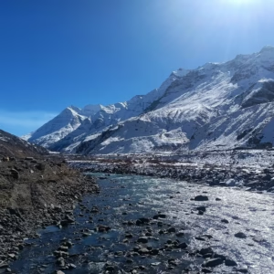
Depending on the season, you may see bare mountains, snow patches, prayer flags, and a road disappearing between the hills.
The weather can change the entire view quickly.
Enjoy the surroundings, but remember that you are at very high altitude. Keep your stop comfortable rather than stretching it unnecessarily.
5. Continue Towards Pangong Lake
For many travellers, the most exciting part comes after Chang La.
Once you cross the pass, you descend towards Tangtse and continue towards Pangong.
Do not think of Chang La and Pangong as two completely separate experiences.
The changing road and landscape between Leh and Pangong are what make the complete journey memorable.
Chang La Pass Route from Leh
The commonly used route is:
Leh → Karu → Sakti → Zingral → Chang La Pass → Tangtse → Pangong Lake
The complete road experience changes section by section.
Leh to Karu
The journey starts relatively easily.
You leave Leh and travel through the Indus Valley side. Compared with the high-altitude section later in the day, this part of the drive usually feels more comfortable.
Use this time to settle into the journey rather than sleeping through the entire route.
Karu to Sakti
From Karu, you turn towards the road leading to Sakti and Chang La.
The landscape gradually starts changing as you move away from the main valley.
Sakti is one of the important settlements on this route before the higher climb begins.
Sakti to Zingral
After Sakti, the climb becomes more noticeable.
The air gets colder, and the road starts feeling more like a high-altitude mountain route.
Depending on current conditions, you may come across rough patches and roadwork.
If you are on a bike, this is where you should become more careful with your speed and energy.
Zingral to Chang La
This is the section where you really start feeling the altitude.
The landscape becomes more open, and weather conditions can change quickly.
Snow, ice, loose gravel, wet sections, or water crossings may appear depending on the season.
Do not rush this section.
Chang La to Tangtse
Once you cross the pass, the road begins descending.
This part of the journey can feel easier physically because you are gradually moving to a lower elevation.
Tangtse is a common stop before continuing towards Pangong.
You can use the stop for food, tea, or a short break depending on your travel plan.
Tangtse to Pangong Lake
From Tangtse, the journey continues towards Pangong Lake.
The landscape changes again as you move deeper into eastern Ladakh.
Do not depend on one fixed travel time for the complete journey. Weather, road repairs, military movement, traffic, and sightseeing stops can all affect your arrival time.
Chang La Pass Road Conditions: What to Expect
One of the most common questions travellers ask is, “Is the Chang La road good?”
There is no single answer.
The road can change throughout the season.
On the same journey, you may find smooth tarmac followed by a broken patch. A little further ahead, there may be gravel, mud, snowmelt, or road construction.
You may experience:
- Smooth paved roads
- Broken sections
- Loose stones and gravel
- Mud
- Snow patches
- Ice during colder conditions
- Seasonal water crossings
- Ongoing road repairs
If you are travelling by motorcycle, keep your speed under control.
Do not brake suddenly on loose gravel.
Maintain enough distance from the vehicle ahead of you.
Before leaving Leh, check your tyres and brakes. Carry basic repair tools and wear proper riding gear.
If you are travelling by taxi, an experienced local driver can make the journey much easier.
Whatever vehicle you choose, check current road conditions before starting.
Best Time to Visit Chang La Pass
May to June
The road generally starts becoming more accessible as conditions improve after winter.
You may still see snow around the higher sections.
However, snowfall or road conditions can still cause temporary closures.
July to August
These are popular months for Ladakh road trips.
Road access is often easier compared with the colder months, but conditions can still change.
Melting snow and changing weather can create wet road sections and water crossings.
September to October
This period can be good if you prefer fewer travellers and cooler weather.
Many days may offer clearer conditions, but temperatures at Chang La start dropping quickly.
Carry proper winter layers even if Leh feels comfortable.
November to April
Winter travel becomes much less predictable.
Heavy snowfall and temporary road closures can affect access.
Do not plan your journey based only on a general seasonal calendar.
Always check the current status of Chang La before leaving Leh.
Best Time of Day to Cross Chang La
Starting early from Leh is usually the better choice.
An early start gives you more daylight and enough buffer if the road is slow.
It also means you do not have to rush your journey towards Pangong.
Road construction, traffic, weather, or a temporary stop can easily add time to the journey.
If you start very late, you may end up reaching Pangong after a long and tiring day.
Keep your schedule flexible and plan the complete journey, not just the time required to reach Chang La.
Acclimatisation Before Visiting Chang La
Do not plan Chang La immediately after landing in Leh.
This is one of the most important things to understand before your Ladakh trip.
Leh itself is already at high altitude. Chang La takes you much higher.
Your body needs time to adjust.
Many Ladakh itineraries keep the first couple of days around Leh and nearby areas before moving towards higher routes.
During your initial time in Leh:
- Rest properly
- Avoid heavy exercise
- Eat regular meals
- Drink enough fluids
- Avoid excessive alcohol
- Pay attention to how your body feels
Hydration is useful, but drinking large amounts of water does not guarantee that you will avoid altitude sickness.
If you have medical concerns about high-altitude travel, speak with a qualified medical professional before your trip.
Altitude Sickness at Chang La: Warning Signs You Should Not Ignore
Altitude sickness can affect anyone.
Fitness does not guarantee protection.
Common symptoms can include headache, dizziness, nausea, unusual tiredness, and shortness of breath.
If you experience mild discomfort at the summit, avoid unnecessary activity and inform your driver or travel companions.
If symptoms become serious or continue getting worse, do not hide them just because you want to reach Pangong.
Going to a lower altitude and getting medical help is more important than completing one day’s itinerary.
Portable oxygen may be useful in certain situations when used appropriately, but it should never be treated as a replacement for proper acclimatisation, descent, or medical care.
Do You Need a Permit for Chang La Pass?
Permit requirements in Ladakh can change depending on your nationality, route, and destination.
Travellers heading towards areas such as Pangong should check the latest requirements issued by the Ladakh administration before starting their journey.
Do not depend on an old blog that says one permit rule applies to everyone.
If a permit is required for your route, keep both digital and physical copies where practical.
A registered travel operator can also help you understand the current requirements.
Chang La Pass by Bike: What Riders Should Know
Crossing Chang La Pass by bike can be one of the most exciting parts of a Ladakh motorcycle trip.
But this is not a road where speed matters.
Preparation matters.
Before leaving Leh, check:
- Tyres
- Brakes
- Fuel
- Basic tools
- Riding gear
- Gloves
- Waterproof layer
- Important spare parts
Keep your speed controlled on broken sections.
Be particularly careful on loose gravel and wet roads.
Do not ride aggressively just because another rider in your group is going faster.
Your bike, riding experience, and physical condition may be different.
The altitude also adds to fatigue.
Take proper breaks at lower elevations when needed instead of spending a long time resting at the summit.
Chang La Pass by Car or Taxi
For first-time Ladakh travellers, hiring a local taxi is often the easier option.
Local drivers regularly use these routes and generally understand the road conditions better.
If you are travelling in your own vehicle or planning a self-drive trip, check the latest local vehicle rules before arriving in Ladakh.
Rules related to outside rental vehicles can change, so do not depend on old information.
The condition of your vehicle also matters.
Do not take a poorly maintained car onto a high-altitude route simply because the road looks good in online photographs.
What to Wear and Carry for Chang La Pass
The weather at Chang La can feel completely different from Leh.
Carry:
- Warm jacket
- Thermal layer when required
- Gloves
- Woollen cap
- Sunglasses
- Sunscreen
- Water
- Light snacks
- Personal medicines
- Government ID
- Required permits
- Power bank
- Basic first-aid kit
Bikers should also carry proper protective riding gear.
Dress in layers.
You may leave Leh feeling comfortable and reach Chang La a few hours later in strong, cold wind.
Places to Visit Near Chang La Pass
The places around Chang La are spread across the route, so do not treat all of them as attractions you can cover in one short stop. The distances below are approximate road distances and may vary slightly depending on the route and road conditions.
Pangong Tso: Around 85–95 km from Chang La
For most travellers, Pangong Tso is the main destination after crossing Chang La.
The road continues through Tangtse and other settlements before reaching the lake region.
Do not rush through Chang La just because you want to reach Pangong quickly. At the same time, avoid spending too long at the summit because you still have a substantial drive ahead.
Tangtse Village: Around 35–40 km from Chang La
Tangtse is one of the most useful stops after descending from the pass.
Depending on your route and schedule, you can stop here for food, tea, or a short break before continuing towards Pangong.
After spending time at very high altitude, many travellers feel more comfortable once they descend towards this side.
Sakti Village: Around 25–35 km from Chang La
Sakti lies on the Leh side of the route and is one of the main villages you pass before climbing towards Chang La.
If you are travelling from Leh, the road starts feeling more remote as you leave Sakti and continue higher.
Hemis Monastery: Around 60–70 km from Chang La
Hemis Monastery is not directly beside Chang La, but it can be included in a wider Ladakh itinerary.
It is better to plan Hemis according to your complete route rather than trying to force it into an already long Leh-Pangong travel day.
Leh: Around 70–80 km from Chang La
Leh is the main starting point for many travellers crossing Chang La.
Although the road distance may not look very long on a map, high-altitude mountain roads take time.
Do not calculate your journey using normal highway driving speeds.
Pangong Region and Changthang
Chang La provides road access towards the wider landscapes of eastern Ladakh and the Pangong side of the Changthang region.
Tso Moriri is also located in the wider Changthang region, but it is not a quick nearby attraction from Chang La.
Plan it as part of a separate route or a wider Ladakh circuit.
How to Add Chang La Pass to Your Ladakh Itinerary
Option 1: Leh to Pangong Lake
This is the most common plan.
Your route will generally look like:
Leh → Karu → Sakti → Chang La → Tangtse → Pangong
You do not need to keep a separate day for Chang La.
It naturally becomes one of the main experiences of your Leh to Pangong road journey.
Option 2: Pangong to Leh
If your itinerary brings you back from Pangong through the same route, you may cross Chang La again in the opposite direction.
Road conditions and your chosen route will decide the final plan.
Option 3: Wider Ladakh Circuit
Some travellers combine Pangong with other parts of eastern Ladakh.
These routes require more planning because road access, fuel availability, permits, and weather conditions can change.
When planning such routes, Trip Guru Go recommends considering altitude and realistic driving time instead of simply adding as many places as possible to one day.
A good Ladakh itinerary should feel comfortable enough to enjoy, not like a race from one location to another.
Common Mistakes to Avoid at Chang La Pass
The first mistake is travelling towards Chang La immediately after landing in Leh.
Your body needs time to adjust.
Another common mistake is spending too long at the summit because everyone is taking photographs.
You should also avoid:
- Running or repeatedly jumping for photos
- Ignoring headache or dizziness
- Starting the Leh-Pangong journey very late
- Wearing only light clothes
- Assuming the road will be the same throughout the season
- Depending on old permit information
- Riding too fast on broken roads
- Treating portable oxygen as a replacement for acclimatisation
- Travelling without checking current road conditions
The easiest way to enjoy Chang La is to prepare properly and keep your plan flexible.
Practical Tips for Crossing Chang La Pass
- Acclimatise properly in Leh before travelling higher.
- Start your journey early.
- Keep your stop at the summit short.
- Walk slowly at the top.
- Avoid unnecessary physical effort.
- Dress in warm layers.
- Carry water and light snacks.
- Check current weather and road conditions.
- Carry the required documents and permits.
- Do not ignore altitude symptoms.
- Listen to your driver if road conditions change.
- Keep extra time in your itinerary.
Final Thoughts: Is Chang La Pass Worth Experiencing?
Yes, but Chang La is not a place you need to visit as a separate sightseeing destination.
Its real experience comes from the complete journey.
You leave the relatively comfortable roads around Leh, climb through Sakti and Zingral, reach the cold and thin air at the summit, and then descend towards the completely different landscapes of eastern Ladakh.
Keep your stop at the top simple. Take a few photographs, visit the temple if you want, look around, and continue when you are ready.
The most important thing is to respect the altitude.
You do not need to spend the longest time at the summit to enjoy Chang La. Prepare properly, travel at a comfortable pace, listen to your body, and enjoy the road towards Pangong.
That complete journey is what you are likely to remember after returning from Ladakh.
Frequently Asked Questions
1. What is Chang La Pass famous for?
Chang La Pass is known for its high altitude and its location on the popular road between Leh and the Pangong Lake region. For most travellers, the mountain pass is an important part of the Leh to Pangong road journey.
2. What is the altitude of Chang La Pass?
Chang La Pass is located at an altitude of around 5,360 metres, or roughly 17,500+ feet. Because of the high elevation, travellers may feel breathless or tired and should avoid unnecessary physical activity at the summit.
3. Which two places does Chang La Pass connect?
Chang La provides an important road connection between the Leh side and eastern Ladakh towards the Pangong region. Most tourists know it as the high mountain pass crossed while travelling from Leh to Pangong Lake.
4. Is Chang La Pass on the route from Leh to Pangong Lake?
Yes. Chang La is on one of the commonly used routes between Leh and Pangong Lake. The usual journey passes through Karu, Sakti, Chang La, and Tangtse before continuing towards Pangong.
5. How far is Chang La Pass from Leh?
Chang La is approximately 70 to 80 km from Leh by road, depending on the exact route. Mountain roads take longer than normal highways, so do not estimate your travel time based only on the distance.
6. How long should I stay at Chang La Pass?
Most travellers only need a short stop of around 10 to 20 minutes if they feel comfortable. You can take photographs and look around before continuing. If you feel dizzy or unwell, do not wait for a fixed amount of time before descending.
7. Is Chang La Pass safe for tourists?
Chang La is regularly crossed by tourists, but high altitude, weather, and changing road conditions require preparation. Acclimatise before the journey, check current road updates, wear warm clothes, and never ignore symptoms of altitude sickness.
8. Is altitude sickness common at Chang La Pass?
Altitude-related discomfort can affect travellers because Chang La is above 5,000 metres. Headache, nausea, dizziness, fatigue, and shortness of breath are possible. Proper acclimatisation helps reduce risk, but anyone with worsening symptoms should descend and seek medical help.
9. How many days should I acclimatise before visiting Chang La?
Many travellers spend the first couple of days around Leh before travelling to much higher places. The right acclimatisation plan can vary between people, so follow current medical guidance and pay attention to how your body responds to altitude.
10. What is the best time to visit Chang La Pass?
Late spring to early autumn is generally the main travel period, but there is no guaranteed opening calendar. Snowfall, road damage, and weather can cause temporary closures, so check the latest road status before leaving Leh.
11. Is Chang La Pass open throughout the year?
Access depends on weather and road conditions. Winter snowfall can make the route difficult or temporarily inaccessible. Even during the main tourist season, short closures can happen, so always check the current status locally.
12. What are the road conditions at Chang La Pass?
Conditions change throughout the season. You may find smooth roads, broken patches, gravel, mud, snow, or water crossings on the same journey. Current road updates are more useful than relying on an old travel report.
13. Can I visit Chang La Pass by bike?
Yes, Chang La is popular among motorcycle travellers. Your bike should be in good condition, and you should carry proper riding gear and basic tools. Ride slowly on loose or broken sections and pay attention to fatigue caused by altitude.
14. Can I cross Chang La Pass by car?
Yes. Cars and taxis use the route, depending on current road conditions. First-time visitors often prefer a local taxi because experienced drivers are familiar with the high-altitude roads and changing conditions.
15. Do I need a permit for Chang La Pass?
Permit rules depend on your nationality, route, and onward destination. If you are travelling towards Pangong or other regulated areas, check the latest Ladakh administration requirements before your trip instead of relying on old permit information.
16. How far is Pangong Lake from Chang La Pass?
The Pangong Lake region is roughly 85 to 95 km from Chang La by road, depending on your final destination around the lake and route conditions. The journey usually continues through the Tangtse side.
17. What should I wear at Chang La Pass?
Wear warm layers, even if the weather in Leh feels comfortable. Carry a warm jacket, gloves, a woollen cap, sunglasses, and suitable footwear. Bikers should wear full protective riding gear.
18. What should I carry while crossing Chang La?
Carry warm clothes, water, light snacks, personal medicines, sunscreen, sunglasses, government ID, applicable permits, a power bank, and basic first aid. Bikers should also carry essential tools and spare items.
19. Is Chang La higher than Khardung La?
Published elevations and historical claims about Ladakh’s motorable passes can vary between sources. Instead of focusing on disputed rankings, treat both as very high-altitude routes where proper acclimatisation and careful travel are important.
20. Can I visit Chang La Pass immediately after reaching Leh?
It is not a good idea to travel directly to Chang La after flying into Leh. Chang La is much higher, and your body needs time to adjust to altitude. Spend time acclimatising in and around Leh before travelling to higher routes.

Anjali is a travel content writer who creates informative and engaging articles about destinations, travel tips, itineraries, and travel experiences. She enjoys simplifying travel information to help readers plan their journeys with confidence while discovering new places and cultures.